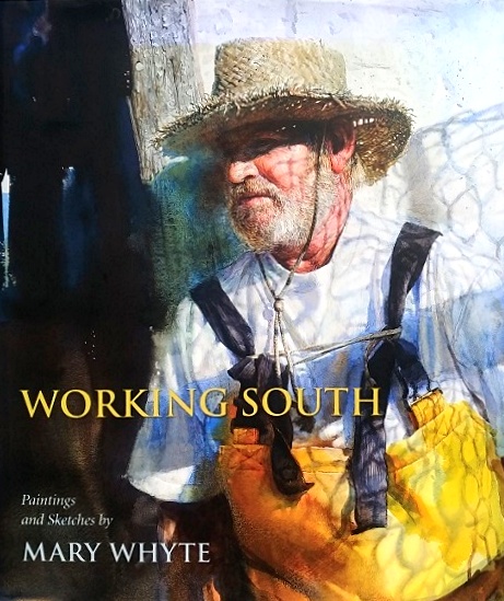
Whyte, Mary; Severens, Martha (Foreword by):Working South: Paintings and Sketches by Mary Whyte
- signed or inscribed book 2022, ISBN: 9781570039669
Paperback, Hardcover
NJ International. Softcover. New. For six decades the Second Avenue Elevated line served communities on the east side of Manhattan, but it never received the attention that was accorded… More...
NJ International. Softcover. New. For six decades the Second Avenue Elevated line served communities on the east side of Manhattan, but it never received the attention that was accorded the other lines. It received greater notice in various trade and engineering journals for it was the line where new technologies were tested. NJ International, softcover, 60 pages, standard landscape book 10 x 8 in., B&W photographs and illustrations., NJ International, 6, Paperback. New. With the Fourth Industrial Revolution of converging genetics, robotics, artificial intelligence, synthetic, biology, nanotechnology, and dimensional spiritual welfare, humanity will be exposed to the most fantastic - most far reaching - supernatural implications. The destiny of each individual and the future of generation will depend on knowledge of the True Being - Jesus Christ. Technology has challenged Christianity and New Testament fundamental precepts abandoned, giving birth to new form of secularized spirituality. Thus, prosperity theology has been elevated instead of theology of the counsel of God. In addition, living by faith defined in the scriptures as centered on the person of Jesus Christ and expressed in personal sacrifice and transformation, this has been changed to thrilling unorthodox theology. The faith that once delivered saints is no longer familiar, not only among the teens, but also in parents. Mankind has begun to play God; but we know God alone is Creator of life. It is for this reason that the New Testament Exhortations book will outline in chapters based on the Sovereignty of God's love to mankind. God is the same yesterday, today and forever and that will never ever change.| Author: Dorothy Mutanu Kagwaini, Ph.d.| Publisher: Partridge Publishing Singapore| Publication Date: Jul 19, 2019| Number of Pages: 398 pages| Language: English| Binding: Paperback| ISBN-10: 1482864509| ISBN-13: 9781482864502, 6, Milan, Italy: Art Stock Books LTD/CSI. New. 1998. Paperback. 8878380393 . Talenti Series; B&W and Color Illustrations; 13.2 X 9.3 X 0.3 inches; 79 pages; Soft cover has self flaps. Black spine with white lettering. Extensively illustrated with color and b/w pictures and drawings. Founded in 1990, Resolution 4 is an architectural firm whose work probes deep into the latest developments in architectural design. Its decision to focus on information and context has led to an in-depth analysis of the main formal and technological languages of late-modern culture. Resolution 4 believes that heroic, solitary architecture has had its day. Oversized, 4#. ., Art Stock Books LTD/CSI, 1998, 6, Milan, Italy: Art Stock Books LTD/CSI. New. 1998. Paperback. 8878380393 . Talenti Series; B&W and Color Illustrations; 13.2 X 9.3 X 0.3 inches; 79 pages; Soft cover has self flaps. Black spine with white lettering. Extensively illustrated with color and b/w pictures and drawings. Founded in 1990, Resolution 4 is an architectural firm whose work probes deep into the latest developments in architectural design. Its decision to focus on information and context has led to an in-depth analysis of the main formal and technological languages of late-modern culture. Resolution 4 believes that heroic, solitary architecture has had its day. Oversized, 4#. ., Art Stock Books LTD/CSI, 1998, 6, Springer-Verlag. Very Good with No dust jacket as issued. 1992. Hardcover. 038797895X . This specific hardback book is in new condition with a hard board cover that has sharp edges and corners and has a tight binding. The pages are clean, crisp, and uncreased but do contain pencil notes of markings throughout. There is no dust jacket. We package all books in custom cardboard book boxes for shipment and ship daily with tracking numbers.; "John Sculley In the short history of personal computing, the task of the software programmer has been one of the least recognized-but one of the most significant-in the industry. In addition to defining the prob lems, and presenting the solutions, the software programmer is con fronted with the challenge of having to predict what combination of ideas and technologies will move the industry forward in the most compelling way. Even though we've seen the development of tremendous applications in a surprisingly short period of time, the most difficult problems often surface when we try to elevate a suc cessful local idea to the international arena. In the case of Apple Computer, these challenges become especially profound when you consider that Apple sells Macintosh not just in the United States, but in Japan, China, the Middle East, Africa, East ern Europe, and even to the United Nations itself. Of course, this means that the personal computer must work everywhere around the world. But more significantly, it also means that the software must reflect the uniqueness of a given culture, its language, morals, and even its sense of humor. To step away from a narrowly-defined, nationally-based paradigm for software development, programmers, management, and entire corporations must learn to recognize what elements of an interface, problem solving technique, documentation illustration, package de sign, and advertisement are local, and which elements are appro priate for global markets."; Ecological Studies, 97 Series; 9.3 X 6.3 X 1.3 inches; 544 pages ., Springer-Verlag, 1992, 3, Elevate Books Edu, 2020. Paperback. New. 204 pages. 9.90x7.90x0.80 inches., Elevate Books Edu, 2020, 6, Puffin. Hardcover. NEW. by Mini Grey About the book: Here we are at 4.6 billion years ago, and as we raise the curtain . . . the STORY OF LIFE is about to begin! (Yes, that's right - we're telling the story of the ENTIRE history of Planet Earth ""In the running for the greatest children's picture book about Earth . . . Grey's jokes and wild imagination elevate this far above the many non-fiction science titles for children"" - THE TIM Take your seats for the ENTIRE history of Planet Earth, as we take a whistle-stop tour from the birth of Earth, to the age of bacteria, the era of dinosaurs . . . to the moment of people (blink and you'll miss it Narrated by a friendly troop of insects and with mind-blowing, lively illustrations, this illustrated non-fiction book will entertain and educate, as we put on a show, the greatest show, the show of the evolution of life on Eart From internationally bestselling creator, Mini Grey, winner of the Kate Greenaway Medal, this is her first non-fiction book and it's told with wit, humour and heart. About Author/s: Mini Grey was given her name after being born in a Mini in a car park in Newport, Wales. She studied for an MA in Sequential Illustration at Brighton under the tutelage of John Vernon Lord. Mini also worked as a primary school teacher in Oxford, where she now lives. Her books include Egg Drop, The Pea and the Princess (shortlisted for the CILIP Kate Greenaway Medal), Biscuit Bear (winner of the Nestl? Children's Book Prize Gold Award), Traction Man is Here (winner of the Boston Horn Book Award and shortlisted for the CILIP Kate Greenaway Medal), The Adventures of the Dish and the Spoon (winner of the Nestl? Children's Book Prize Bronze Award and winner of the CILIP Kate Greenaway Medal), and Traction Man meets Turbodog. Mini Grey is one of the Big Picture's ten Best New Illustrators. Author: Mini Grey ISBN 13: 9780241480830 Language: English Published by: Puffin Format: Hardcover Year: 2022 Number of pages: 48 Weight: 532 g Narrative: Non-Fiction Genre: Children's Science, Nature & Technology Topic: Children's Book Intended Audience: Ages 4-8, Ages 9-12 Country of Origin: India, Puffin, 6, Hong Kong: Design Media Publishing LTD, 2013. English Text. Hong Kong, 2013; clothbound, pp. 256, col. ill., col. plates, cm 24x31. In the recent ten years in China, with the nationwide strategy of 'invigorating the country through science, technology and education', the implementation of compulsory education, and the rapid development of economy, educational architecture including universities, colleges, middle schools and primary schools has been growing at an unprecedented pace. Projects included in 'School Buildings' are accompanied with colour photographs, plans, sections and elevations, as well as numerous construction details. There is also a descriptive text and in-depth information for each project., Design Media Publishing LTD, 2013, 0, Washington DC: National Geographic Society, 1925. Presumed First Edition/First Printing thus. Single sheet, printed on one side. Fair. Approximately 13 inches by 19 inches. Has color. Majority of the map is for Maryland/District of Columbia and Delaware, with inserts on Washington and Vicinity, Baltimore and Vicinity, and Wilmington and Vicinity. Scale is 1:900,000 or 14.2 miles to 1 inch. This map was prepared for the National Geographic Magazine. Folded into 6 panels ( three larger than the other three, one sided). Several tears at edges and folds. Back side has noticeable soiling. Founded in 1915 as the Map Department of the National Geographic Society, National Geographic Maps is responsible for illustrating the world around us through the art and science of mapmaking. Today, National Geographic Maps continues this mission by creating the world's best wall maps, outdoor recreation maps, travel maps, atlases and globes that inspire people to care about and explore their world. A map is a symbolic representation of selected characteristics of a place, usually drawn on a flat surface. Maps present information about the world in a simple, visual way. They teach about the world by showing sizes and shapes of countries, locations of features, and distances between places. Maps can show distributions of things over the Earth, such as settlement patterns. They can show exact locations of houses and streets in a city neighborhood. Mapmakers, called cartographers, create maps for many different purposes. Vacationers use road maps to plot routes for their trips. Meteorologists-scientists who study the weather-use weather maps to prepare forecasts. City planners decide where to put hospitals and parks with the help of maps that show land features and how the land is currently being used. Some common features of maps include scale, symbols, and grids.��All maps are scale models of reality. A map's scale indicates the relationship between the distances on the map and the actual distances on Earth. This relationship can be expressed by a graphic scale, a verbal scale, or a representative fraction. The most common type of graphic scale looks like a ruler. Also called a bar scale, it is simply a horizontal line marked off in miles, kilometers, or some other unit of measuring distance. The verbal scale is a sentence that relates distance on the map to distance on Earth. For example, a verbal scale might say, "One centimeter represents one kilometer" or "One inch represents eight miles." The representative fraction does not have specific units. It is shown as a fraction or ratio-for example, 1/1,000,000 or 1:1,000,000. This means that any given unit of measure on the map is equal to one million of that unit on Earth. So, 1 centimeter on the map represents 1,000,000 centimeters on Earth, or 10 kilometers. One inch on the map represents 1,000,000 inches on Earth, or a little less than 16 miles. The size of the area covered helps determine the scale of a map. A map that shows an area in great detail, such as a street map of a neighborhood, is called a large-scale map because objects on the map are relatively large. A map of a larger area, such as a continent or the world, is called a small-scale map because objects on the map are relatively small.��Cartographers use symbols to represent geographic features. For example, black dots represent cities, circled stars represent capital cities, and different sorts of lines represent boundaries, roads, highways, and rivers. Colors are often used as symbols. Green is often used for forest, tan for deserts, and blue for water. A map usually has a legend, or key, that gives the scale of the map and explains what the various symbols represent. Some maps show relief, or changes in elevation. A common way to show relief is contour lines, also called topographic lines. These are lines that connect points that have equal elevation. If a map shows a large enough area, contour lines form circles. A group of contour line circles inside one another indicates a change in elevation. As elevation increases, these contour line circles indicate a hill. As elevation decreases, contour line circles indicate a depression in the earth, such as a basin. Many maps include a grid pattern, or a series of crossing lines that create squares or rectangles. The grid helps people locate places on the map. On small-scale maps, the grid is often made up of latitude and longitude lines. Latitude lines run east-west around the globe, parallel to the Equator, an imaginary line that circles the middle of the Earth. Longitude lines run north-south, from pole to pole. Latitude and longitude lines are numbered. The intersection of latitude and longitude lines, called coordinates, identify the exact location of a place. Along with scale, symbols, and grids, other features appear regularly on maps. A good way to remember these features is DOGSTAILS: date, orientation, grid, scale, title, author, index, legend, and sources. Title, date, author, and sources usually appear close to one another. The map's title tells what the map is about, revealing the map's purpose and content. For example, a map might be titled "Battle of Gettysburg, 1863." "Date" refers to either the time the map was made or the date relevant to the information on the map. Noting a map's author is important because the cartographer's perspective will be reflected in the content. Assessing accuracy and objectivity also requires checking sources. A map's sources are where the author of the map got his or her information. A map of a school district may list the U.S. Census Bureau, global positioning system (GPS) technology, and the school district's own records as its sources. Orientation refers to the presence of a compass rose or simply an arrow indicating directions on the map. If only an arrow is used, the arrow usually points north. A map's index helps viewers find a specific spot on the map using the grid. A map's legend explains what the symbols on a map mean., National Geographic Society, 1925, 2, Columbia, SC: University of South Carolina Press, 2011 Cloth, xv, 110 pages, illustrations (some colour); 30 cm. PRESENTATION COPY. Signed by the artist, with a personalized inscription. A fine copy. Dust jacket protected in a mylar cover. OVERSIZE! No priority/international, except by arrangement. Richly illustrated with colour plates. "In Working South, renowned watercolorist Mary Whyte captures in exquisite detail the essence of vanishing blue-collar professions from across ten states in the American South with sensitivity and reverence for her subjects. From the textile mill worker and tobacco farmer to the sponge diver and elevator operator, Whyte has sought out some of the last remnants of rural and industrial workforces declining or altogether lost through changes in our economy, environment, technology, and fashion. She shows us a shoeshine man, a hat maker, an oysterman, a shrimper, a ferryman, a funeral band, and others to document that these workers existed and in a bygone era were once ubiquitous across the region. 'When a person works with little audience and few accolades, a truer portrait of character is revealed,' explains Whyte in her introduction. As a genre painter with skills and intuition honed through years of practice and toil, she shares much in common with the dedication and character of her subjects. Her vibrant paintings are populated by men and women, young and old, black and white to document the range southerners whose everyday labors go unheralded while keeping the South in business. By rendering these workers amid scenes of their rough-hewn lives, Whyte shares stories of the grace, strength, and dignity exemplified in these images of fading southern ways of life and livelihood. Working South includes a foreword by Martha Severens, curator of the Greenville County Museum of Art in Greenville, South Carolina." - Publisher.. SIGNED. Hardcover. Very Good/Fine. 4to - over 9¾" - 12" tall. Collectible., University of South Carolina Press, 2011, 4<